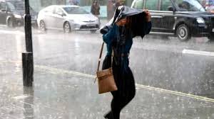
Heavy Rainfall and Flash Floods Threaten South-East England as Thunderstorms Sweep in from France
As parts of the UK brace for a dangerous weekend of weather chaos, the Met Office has issued a rare amber thunderstorm warning for London and much of south-east England, citing a “danger to life” from potential flash flooding and extreme lightning.
This sudden shift comes after weeks of erratic climate behavior, including England’s hottest June on record. Now, storm systems moving in from France are set to drench large swathes of the country, with urban areas like London particularly vulnerable due to their impermeable infrastructure.
What’s Driving the Weather Crisis This Weekend?
French Thunderstorms Collide with UK Summer
The root of this weekend’s disruption lies in a band of intense thunderstorms sweeping northward from France, bringing with them a heavy deluge. This meteorological convergence is expected to create high-intensity downpours, with surface water flooding and travel disruption highly likely.
Amber Warning (London & South-East England)
-
When: Saturday, 4am to 11am
-
Rainfall Expectation: Up to 40mm in an hour, potentially 70–100mm over several hours
-
Impacts:
-
Dangerous surface flooding
-
Frequent lightning strikes
-
Rapid water accumulation in low-lying areas
-
Travel chaos across rail and road
-
This is London’s first amber warning since Storm Henk in January 2024, a clear signal that extreme weather events are no longer seasonal anomalies—they’re becoming systemic.
Broader UK Warnings – Yellow Alert Zones and Implications
Yellow Thunderstorm Warning Across England
A widespread yellow alert is in effect until 9pm Saturday, encompassing much of England. Forecasts show 15 to 25mm of rain could fall within an hour, creating dangerous driving conditions and possible localized flooding.
Scotland Not Spared
The north isn’t off the hook either—Scotland faces a yellow warning for rain from Saturday 4pm through Sunday midday, signaling a weekend of interrupted travel, events, and economic activity across the UK.
Why London Is Especially at Risk
Urban Drainage Systems Under Pressure
London is a notorious hotspot for flash flooding, not because of its geography, but due to its infrastructure. The capital’s dense concentration of **impermeable surfaces—roads, pavements, rooftops—**prevents water from draining efficiently.
During intense rainfall:
-
Water pools rapidly in streets and underpasses
-
Sewers and storm drains are overwhelmed
-
Transit networks like the Underground suffer from closures and delays
This is not theoretical—it’s happened repeatedly, most memorably in July 2021, when central London saw cars submerged, homes flooded, and hospitals evacuated.
Met Office Cautions: Prepare for Rapid Escalation
Met Office Chief Meteorologist Andy Page cautioned that the situation is fluid, and additional warnings or changes to existing alerts are likely.
“The situation is evolving, and warnings may be changed or added,” Page said.
In other words: this isn’t over. British businesses, households, and transportation planners should remain hyper-vigilant through Sunday.
Summer Holidays Collide with Storm Season
The timing couldn’t be worse. With schools in England and Wales breaking for summer holidays, road traffic is expected to skyrocket over the weekend.
Motorists are being urged to:
-
Avoid unnecessary travel during warning periods
-
Check for local disruptions and road closures
-
Slow down and avoid flooded routes, even shallow water
Travel insurance providers are also on alert, with claims expected to rise for trip cancellations, car damage, and home insurance due to flooding.
Long-Term Outlook – Climate Change Turns Up the Heat
Record-Breaking Weather Is Now the Norm
This week, UK scientists reinforced what many already suspect: climate change is fundamentally altering the nation’s weather patterns.
Data from the UK Met Office and academic partners shows:
-
The UK has experienced record temperatures and rainfall events over the past decade
-
The 1884–2024 weather record shows clear warming trends, especially in summer months
-
The increased intensity and frequency of thunderstorms and flooding is directly linked to fossil fuel emissions
CEOs, Local Governments Must Prepare for Recurring Extremes
From urban drainage redesign to supply chain contingency planning, leadership teams across sectors must internalize a key reality: extreme weather is not a one-off. It’s the business climate from now on.
As global temperatures rise, London and other major urban centers must prepare for:
-
Increased frequency of amber and red alerts
-
Higher insurance costs
-
More regulatory pressure to adopt climate-resilient practices
-
Rising infrastructure repair bills
Silver Lining? Some Sun Between Storms
Not all is gloom. Despite Saturday’s chaotic forecast, spells of sunshine are possible throughout the weekend in some parts of the UK, particularly between storm systems. Temperatures may reach the mid-to-high 20s in southern regions, offering short-lived warmth between the rains.
But forecasters warn: don’t be fooled by brief clear skies. The systems are fast-moving, and further storms could redevelop with little warning.
This Is the New Normal—And the UK Must Adapt
With climate records falling and storm alerts rising, the UK is facing a sobering reality: dangerous weather isn’t coming—it’s here.
Whether you’re a household in London, a CEO overseeing logistics, or a policymaker shaping the next infrastructure plan, the message is clear: prepare for a future where amber warnings and flash floods are just another part of summer.